
Download
- Bulk download (90m, 250m, 500m, and 1 km):
https://drive.google.com/drive/folders/0B_J08t5spvd8RWRmYmtFa2puZEE - Use in Google Earth Engine:
https://developers.google.com/earth-engine/datasets/catalog/CGIAR_SRTM90_V4
Introduction
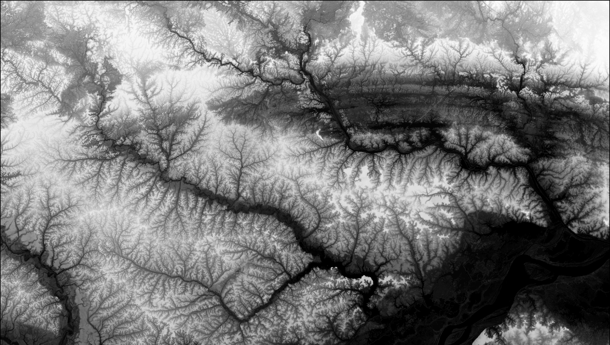
The SRTM digital elevation data provided on this site has been processed to fill data voids and to facilitate its ease of use by a wide group of potential users. This data is provided in an effort to promote the use of geospatial science and applications for sustainable development and resource conservation in the developing world. Digital elevation models (DEM) for the entire globe, covering all of the countries of the world, are available for download on this site.
The SRTM 90m DEM’s have a resolution of 90m at the equator, and are provided in mosaiced 5 deg x 5 deg tiles for easy download and use. All are produced from a seamless dataset to allow easy mosaicing. These are available in both ArcInfo ASCII and GeoTiff format to facilitate their ease of use in a variety of image processing and GIS applications. Data can be downloaded using a browser or accessed directly from the FTP site. If you find this digital elevation data useful, please let us know at csi@cgiar.org.
The NASA Shuttle Radar Topographic Mission (SRTM) has provided digital elevation data (DEMs) for over 80% of the globe. This data is currently distributed free of charge by USGS and is available for download from the National Map Seamless Data Distribution System, or the USGS FTP site. The SRTM data is available as 3 arc second (approx. 90m resolution) DEMs. A 1 arc second data product was also produced but is not available for all countries. The vertical error of the DEM’s is reported to be less than 16m. The data currently being distributed by NASA/USGS (finished product) contains “no-data” holes where water or heavy shadow prevented the quantification of elevation. These are generally small holes, which nevertheless render the data less useful, especially in fields of hydrological modeling.
Andy Jarvis and Edward Guevara of the CIAT Agroecosystems Resilience project, Hannes Isaak Reuter (JRC-IES-LMNH) and Andy Nelson (JRC-IES-GEM) have further processed the original DEMs to fill in these no-data voids. This involved the production of vector contours and points and the re-interpolation of these derived contours back into a raster DEM. These interpolated DEM values are then used to fill in the original no-data holes within the SRTM data. These processes were implemented using Arc/Info and an AML script. The DEM files have been mosaiced into a seamless near-global coverage (up to 60 degrees north and south), and are available for download as 5-degree x 5-degree tiles, in a geographic coordinate system – WGS84 datum. These files are available for download in both Arc-Info ASCII format, and as GeoTiff, for easy use in most GIS and Remote Sensing software applications. In addition, a binary Data Mask file is available for download, allowing users to identify the areas within each DEM which has been interpolated.
Methodology
The first release of Shuttle Radar Topography Mission (SRTM) data was provided in 1-degree digital elevation model (DEM) tiles from the USGS FTP server (ftp://e0srp01u.ecs.nasa.gov/srtm/) in 2003. The data was released continent by continent, as and when the data was processed by NASA and the USGS. For the United States, data was made available at 1-arc second resolution (approximately 30m at the equator), but for the rest of the world, the 1-arc second product is degraded to 3-arc seconds (approximately 90m at the equator). SRTM elevation data has now been released for the entire terrestrial surface, and a “Finished” product has now been released (ftp://e0srp01u.ecs.nasa.gov/srtm/version2/SRTM3/).
In this website, the Consortium for Spatial Information (CGIAR-CSI) of the Consultative Group for International Agricultural Research (CGIAR) is offering post-processed 3 arc-second DEM data for the globe. The original SRTM data has been subjected to a number of processing steps to provide seamless and complete elevational surfaces for the globe. In its original release, SRTM data contained regions of no-data, specifically over water bodies (lakes and rivers), and in areas where insufficient textural detail was available in the original radar images to produce three-dimensional elevational data. There are a total of 3,436,585 voids accounting for 796,217 km2, and in extreme cases, such as Nepal they constitute 9.6% of the country area with some 32,688 voids totaling an area of 13,740 km2. No-data regions due to insufficient textural detail were especially found in mountainous regions (Himalayas and Andes, for example), or desertic regions (e.g. Sahara). The existence of no-data regions in a DEM causes significant problems in using SRTM DEMs, especially in the application of hydrological models which require continuous flow surfaces. For the CGIAR-CSI SRTM data product, we apply a hole-filling algorithm to provide continuous elevational surfaces. The data is projected in a Geographic (Lat/Long) projection, with the WGS84 horizontal datum and the EGM96 vertical datum.
We follow the method described by Reuter et al. (2007). The first processing stage involves importing and merging the 1-degree tiles into continuous elevational surfaces in ArcGRID format. The second process fills small holes iteratively, and the cleaning of the surface to reduce pits and peaks. The third stage then interpolates through the holes using a range of methods. The method used is based on the size of the hole, and the landform that surrounds it. The processing is made using Arc/Info AML model.
Specifically:
- The original SRTM DEM (finished grade data downloaded from ftp://e0srp01u.ecs.nasa.gov/srtm/version2/SRTM3/ is used to produce contours or points (depending on the interpolation methodology to be used for the void). Processing was made on a void by void basis.
- In cases when a higher resolution auxiliary DEM was available, a point coverage is produced of the elevation values at the center of each cell of the auxiliary DEM within void areas. When no high-resolution auxiliary DEM is available, the 30 second SRTM30 DEM is used as an auxiliary for large voids.
- For areas with a high-resolution auxiliary DEM: The contours and points surrounding the hole and inside the hole are interpolated to produce a hydrologically sound DEM using the TOPOGRID algorithm in Arc/Info. TOPOGRID is based upon the established algorithms of Hutchinson (1988; 1989), designed to use contour data (and stream and point data if available) to produce hydrologically sound DEMs. This process interpolates through the no-data holes, producing a smooth elevational surface where no data was originally found. Drainage enforcement is activated, and the tolerances set at 5 for “tolerance 1”, representing the density and accuracy of input topographic data, and a horizontal standard error of 1m and vertical standard error of 0m.
- For areas without a high-resolution auxiliary DEM: The most appropriate interpolation technique is selected based on void size and landform typology, and applied on the data immediately surrounding the hole, using SRTM30 derived points inside the hole should it be of a certain size or greater. The best interpolations methods can be generalised as Kriging or Inverse Distance Weighting interpolation for small and medium-size voids in relatively flat low-lying areas; Spline interpolation for small and medium-sized voids in high altitude and dissected terrain; Triangular Irregular Network or Inverse Distance Weighting interpolation for large voids in very flat areas, and an advanced Spline Method (ANUDEM) for large voids in other terrains.
- The interpolated DEM for the no-data regions is then merged with the original DEM to provide continuous elevational surfaces without no-data regions. This entire process is performed for tiles with the large overlap with neighboring tiles, thus ensuring seamless and smooth transitions in topography in large void areas.
The resultant seamless dataset is then clipped along coastlines using the Shorelines and Water Bodies Database (SWBD). This dataset is very detailed along shorelines and contains all small islands. More information about this dataset is available in USGS (2006c).
Auxiliary DEMs were available from the following sources:
- USA: NED 3-arc-second digital elevation model for mainland USA, Alaska, Hawaii and Puerto Rico. Available fromhttp://seamless.usgs.gov
- Mexico: 90m DEM available from http://www.inegi.gob.mx/geo/default.asp
- Canada: Canadian Digital Elevation Data Level 1derived from 1:50,000 and 1:250,000 topographic maps, available from http://www.geobase.ca/geobase/en/data/cded1.html
- New Zealand: 100m DEM made kindly available by Geographx (http://www.geographx.co.nz/downloads.html)
- Australia: GEODATA TOPO 100k contour data, interpolated to produce a 90m DEM available form http://www.ga.gov.au/products
- Mountainous areas in Central Asia, China, Europe, Caucasus, Northern Andes and Southern Andes based on data from Jonathan de Ferranti’s webpage: http://www.viewfinderpanoramas.org/dem3.html
- Costa Rica: 50m DEM derived from digitized topographic maps made available to CIAT by Antonio Trabucco.
- Ecuador: 90m DEM derived from digitized topographic maps available from http://www.savgis.org/ecuador.htm#DEM.
- Global: Where other auxiliary DEMs were not available, the SRTM30 1km product was used as an auxiliary DEM (USGS, 2006d).
This method produces a smooth elevational surface of no-data regions. Whilst micro-scale topographic variation is not captured using this method, most macro-scale features are captured in small-intermediate sized holes. Jarvis et al. (2004) (available here) make a detailed analysis of the accuracy of the interpolated elevational data in a region in Colombia with 43% of the region containing no-data in the original SRTM release. They find an average vertical error of just 5m in interpolated regions when compared with a DEM derived from cartographic maps, though the maximum error stretches to 257m in a region with approximately 1500m elevation. When hydrological models are applied to the interpolated DEM and the cartographic DEM, little difference is found in hydrological response in terms of overland flow and discharge.
The method presented here for filling in the no-data holes in the original SRTM release is by no means the only method available. For a complete review of methods for hole-filling in SRTM data, readers are referred to an article produced by the Alpine Mapping Guild, Gamache (2004). Martin Gamache has since produced some detailed analysis of the data offered here by the CSI, concluding that the hole-filling algorithm is quite successful in representing broad-scale patterns in topography in data holes. A detailed evaluation of the hole-filling methodology is available at http://www.terrainmap.com/downloads/Gamache_final_web.pdf.
Acknowledgments
- King’s College London (Mark Mulligan) mirrors the data and has created a Google Earth Interface for browsing and downloading SRTM tiles. it also provides smaller (1 by 1 degree) tiles for users who have difficulty with the 5×5 degree tiles as well as 2D and 3D visualization of the data.
- Joint Research Center in the Institute for Environmental Research. We would like to thank the colleagues in the Land Management and Natural Hazards Unit and the Global Environmental Monitoring unit for their support to provide this data.
- HarvestChoice provides the US-based mirror site and a Google Maps-mashup interface.
- The CGIAR-CSI SRTM website was created under the guidance of Robert Zomer, and the support of the International Water Management Institute (IWMI). Database search, data display, and download programming were implemented by GENESIIS Software. Many thanks to CGNET for hosting the database and tech support.
- Funding for this project has been provided by the CGIAR ICT-KM Program: ICT for Tomorrow’s Science Initiative.
Citation
- Jarvis, A., H.I. Reuter, A. Nelson, E. Guevara, 2008, Hole-filled SRTM for the globe Version 4, available from the CGIAR-CSI SRTM 90m Database (http://srtm.csi.cgiar.org).
Version History
Change from Version 3 to Version 4
- Version 4 uses a number of interpolations techniques, described by Reuter et al. (2007)
- Version 4 uses extra auxiliary DEMs to fill the voids and SRTM30 for large voids
- Version 4 differs from Version 3 with a ½ grid pixel shift which definitively solves this confusion.
Change from Version 2 to Version 3
- Version 3 includes Finished grade SRTM data
- Version 3 uses the SWBD database to clip the coastlines
- Version 3 uses auxiliary DEMs to fill the voids
- Version 3 differs from Version 2 with a ½ grid pixel shift
Changes from Version 1 to Version 2
- Version 2 includes DEM data for Australasia and small islands in the Atlantic, Indian and Pacific Oceans.
- Version 2 has the shorelines clipped.
- Version 2 have no “cliffs” on tile joins, brought about by insufficient overlap in interpolation in Version 1.
Known issues and future improvements
- We plan to continue improving the data as and when high-resolution auxiliary datasets become available. Updates are planned that will use high-resolution ASTER DEMs for filling holes in particularly troublesome areas (Sahara, for example).
Disclaimer
DATASET: The data distributed here are in ARC GRID, ARC ASCII, and Geotiff format, in decimal degrees and datum WGS84. They are derived from the USGS/NASA SRTM data. CIAT have processed this data to provide seamless continuous topography surfaces. Areas with regions of no data in the original SRTM data have been filled using interpolation methods described by Reuter et al. (2007).
DISTRIBUTION: Users are prohibited from any commercial, non-free resale, or redistribution without explicit written permission from CIAT. Users should acknowledge CIAT as the source used in the creation of any reports, publications, new datasets, derived products, or services resulting from the use of this dataset. CIAT also request reprints of any publications and notification of any redistributing efforts. For commercial access to the data, send requests to Andy Jarvis.
NO WARRANTY OR LIABILITY: CIAT provides these data without any warranty of any kind whatsoever, either express or implied, including warranties of merchantability and fitness for a particular purpose. CIAT shall not be liable for incidental, consequential, or special damages arising out of the use of any data.
ACKNOWLEDGMENT AND CITATION: We kindly ask any users to cite this data in any published material produced using this data, and if possible link web pages to the CIAT-CSI SRTM website (http://srtm.csi.cgiar.org).
REFERENCE: Reuter H.I, A. Nelson, A. Jarvis, 2007, An evaluation of void filling interpolation methods for SRTM data, International Journal of Geographic Information Science, 21:9, 983-1008 (PDF).
References
- Gamache, M. (2004). Free and Low-Cost Datasets for International Mountain Cartography,http://www.icc.es/workshop/abstracts/ica_paper_web3.pdf.
- Hutchinson, M. (1988). Calculation of hydrologically sound digital elevation models. Third International Symposium on Spatial Data Handling, Columbus, Ohio, International Geographical Union.
- Hutchinson, M. (1989). “A new procedure for gridding elevation and stream line data with automatic removal of spurious pits.” Journal of Hydrology 106: 211-232.
- Jarvis, A., J. Rubiano, A. Nelson, A. Farrow and M. Mulligan (2004). Practical use of SRTM data in the tropics: Comparisons with digital elevation models generated from cartographic data. Working Document no. 198. Cali, International Centre for Tropical Agriculture (CIAT): 32.
- Reuter H.I, A. Nelson, A. Jarvis, 2007, An evaluation of void filling interpolation methods for SRTM data, International Journal of Geographic Information Science, 21:9, 983-1008.
- USGS, 2006a, Shuttle Radar Topography Mission (SRTM) “Finished” 3-arc second SRTM Format Documentation, Available online at http://edc.usgs.gov/products/elevation/srtmbil.html (accessed 01/08/2006).
- USGS, 2006b, Shuttle Radar Topography Mission DTED® Level 1 (3-arc second) documentation, Available online at http://edc.usgs.gov/products/elevation/srtmdted.html (accessed 01/08/2006).
- USGS, 2006c, Shuttle Radar Topography Mission Water Body Dataset, Available online at:http://edc.usgs.gov/products/elevation/swbd.html (accessed 01/08/2006).
- USGS, 2006d, SRTM30 Documentation, Available online at:ftp://e0srp01u.ecs.nasa.gov/srtm/version2/SRTM30 (accessed 01/08/2006).
- Wessel, P., and W. H. F. Smith, A Global Self-consistent, Hierarchical, High-resolution Shoreline Database, J. Geophys. Res., 101, #B4, pp. 8741-8743, 1996.
Publications
Recently published studies that used our SRTM data (let us know if we missed yours!):
- Lin, S., Jing, C., Coles, N. A., Chaplot, V., Moore, N. J., & Wu, J. (2013). Evaluating DEM source and resolution uncertainties in the Soil and Water Assessment Tool. Stochastic Environmental Research and Risk Assessment, 27(1), 209–221. https://doi.org/10.1007/s00477-012-0577-x
- Drăguţ, L., & Eisank, C. (2012). Automated object-based classification of topography from SRTM data. Geomorphology, 141–142, 21–33. https://doi.org/10.1016/j.geomorph.2011.12.001
- Plasencia Sánchez, E., & Fernandez de Villarán, R. (2012). SRTM 3″ comparison with local information: Two examples at the national level in Peru. Journal of Applied Geodesy, 6(2). https://doi.org/10.1515/jag-2011-0016
- Khan, A. (2012). Geology and Geomorphology of the Manipur Valley Using Digitally Enhanced Satellite Image and SRTM DEM in the Eastern Himalaya, India. International Journal of Geosciences, 03(25), 1010–1018. https://doi.org/10.4236/ijg.2012.325101
- Hirt, C., Filmer, M. S., & Featherstone, W. E. (2010). Comparison and validation of the recent freely available ASTER-GDEM ver1, SRTM ver4.1 and GEODATA DEM-9S ver3 digital elevation models over Australia. Australian Journal of Earth Sciences, 57(3), 337–347. https://doi.org/10.1080/08120091003677553
- Mouratidis, A., Briole, P., & Katsambalos, K. (2010). SRTM 3″ DEM (versions 1, 2, 3, 4) validation by means of extensive kinematic GPS measurements: a case study from North Greece. International Journal of Remote Sensing, 31(23), 6205–6222. https://doi.org/10.1080/01431160903401403
- Gorokhovich, Y., & Voustianiouk, A. (2006). Accuracy assessment of the processed SRTM-based elevation data by CGIAR using field data from USA and Thailand and its relation to the terrain characteristics. Remote Sensing of Environment, 104(4), 409–415. https://doi.org/10.1016/j.rse.2006.05.012
- Ricaurte, L., Jokela, J., Siqueira, A., Núñez-Avellaneda, M., Marin, C., Velázquez-Valencia, A., & Wantzen, K. (n.d.). Wetland Habitat Diversity in the Amazonian Piedmont of Colombia. Wetlands, 1–14. https://doi.org/10.1007/s13157-012-0348-y

You must be logged in to post a comment.